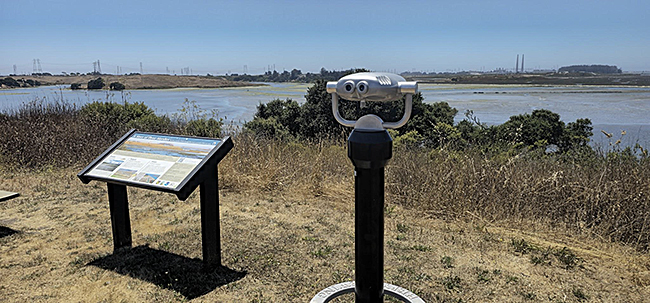
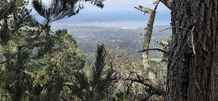
Since 1892, the Sierra Club has been the largest and most influential grassroots environmental organization in the United States. Ventana Chapter members are approximately 6000 of your friends and neighbors. Inspired by nature, we work together to protect our 127 miles of coastline, hundreds of thousands of acres of wild lands and our dwindling water supplies. (Ventana Wilderness from Bottchers Gap, Ventana Chapter file photo).

New Hike!
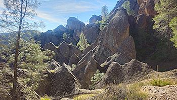
Pinnacles High Peaks & Balconies Cave Loop
Saturday, April 18, 2026
9:00 AM - 3:30 PM
Pinnacles National Park
Join us for an epic journey through the heart of California’s youngest National Park. This strenuous loop captures the two most iconic experiences Pinnacles has to offer: the adrenaline-pumping "Steep and Narrow" section of the High Peaks and the subterranean adventure of the Balconies talus caves.
This route is designed for experienced hikers looking for a full day of diverse terrain, from volcanic spires to dark, boulder-filled passages.
What to Expect:
•
The High Peaks "Steep and Narrow": We will ascend into the park’s famous volcanic rock formations. This section features spectacular stairs and handrails carved directly into the steep rock faces. It’s a thrilling, "top-of-the-world" experience that offers the best chance to spot the majestic California Condors soaring on thermal updrafts. We will break for lunch at the top.
• Balconies Cave Exploration: After descending from the peaks, we’ll transition from sky to stone as we enter the Balconies Cave. This is a "talus cave," formed by massive boulders falling into a narrow canyon. We will navigate through dark chambers and scramble over rocks (headlamps are mandatory!).
**Ancient Volcanic Vistas: Throughout the hike, you’ll be surrounded by the jagged remains of an ancient volcanic field that has traveled hundreds of miles along the San Andreas Fault. The panoramic views of the surrounding wilderness are unparalleled. Here is the Alltrails link https://www.alltrails.com/explore/custom-routes/custom-route-high-peaks-balconies-cave-loop-3ac63e4?u=i&sh=w4bcfp**
**Meet: At the Pinnacle Moses Spring Parking Area. Use the East entrance past Hollister. There are multiple parking lots on that road. The trailhead is at the last one. https://maps.app.goo.gl/WZam9qc7AQAQfVi59
Note: This is not an official Sierra Club outing. Everyone is welcome to join.
For more information and to RSVP Click Here
Hosted by Ryan Trundle, Email
|
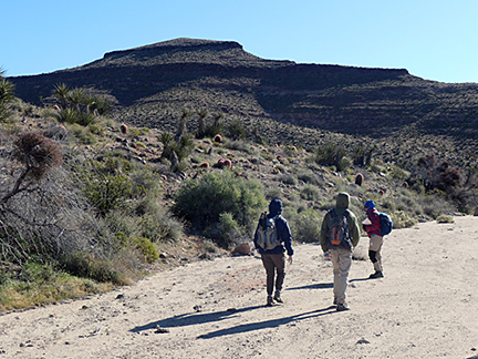
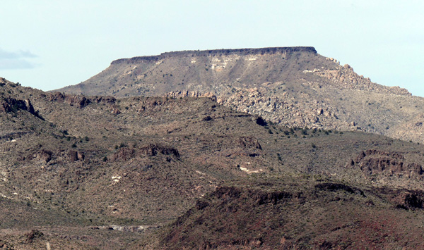 Table Top looks unclimbable from a distance. This photo was taken from the summit of Tortoise Shell. Table Top looks unclimbable from a distance. This photo was taken from the summit of Tortoise Shell.
Table Top, 6178'
March 4, 2026
by Debbie Bulger
This iconic peak stands dramatically on the landscape and can be seen from many vantagepoints. Richard Stover, Med, Carmelita and I drove to the 4WD road from Hole-in-the-Wall Campground and started hiking from Black Canyon Road at 8:30 a.m. since the start of the primitive road was too rough for our vehicle.
Table Top is a remnant of a huge volcanic explosion about 18 million years ago leaving piles of volcanic ash and rocks. The steep cliffs of the peak surround an expansive plateau on the top which invites exploration. A fire 20 years ago left numerous skeletons of pine and juniper, but miraculously on the flat summit, many trees survive.
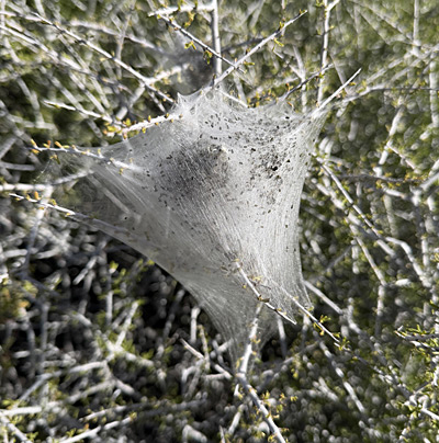
After walking for a short while on the primitive road (good after the first rough spots), we travelled cross-country paralleling the west ridge heading for a cove at the base of the peak below a break in the cliff above. On the way we spotted interesting caterpillar tents on the shrubs. Are these the overwintering shelters of Western Tent Caterpillars? I think so. When the larvae mature, they commence to eat the leaves of the shrub, eventually make a chrysalis, and finally emerge as a brown moth.
|
There were many caterpillar tents on the shrubs. |
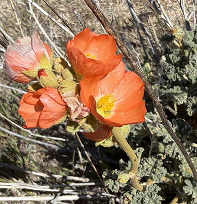
Desert Mallow was just beginning to bloom. |
The most unusual item we encountered on our hike was a volcanic rock with prominent raised veins. Do you know how it was created? Please let me know. |
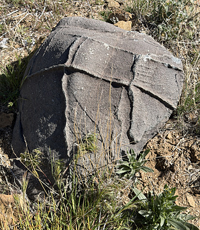
Can you tell me how this rock was formed? Looks like the creator was playing tic tac toe. |
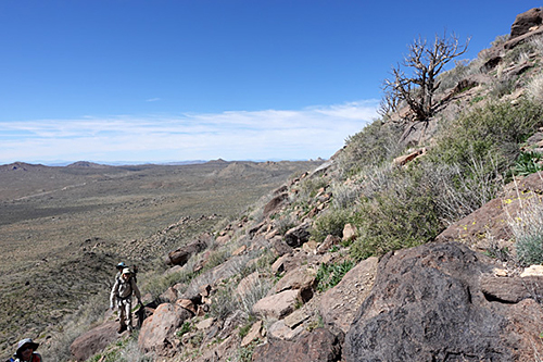
Near the top it became very steep.
Most of the climb was moderate until we reached a very steep area at the break in the cliffs. |
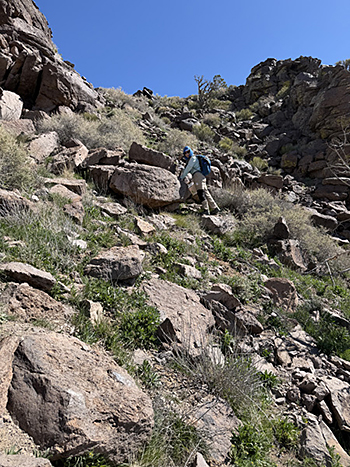
We climbed up to a break in the cliffs. |
I was surprised when suddenly I topped out at the summit. Usually when climbing a peak, one can see the summit ahead. Not so in this case. We were there. |
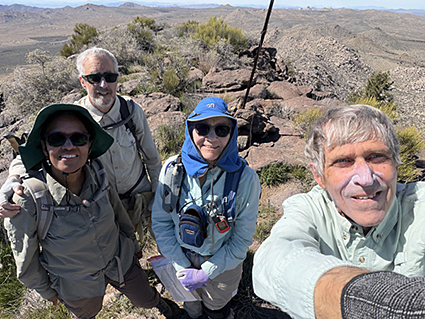
On the summit. From left: Carmelita, Med, Debbie, Richard |
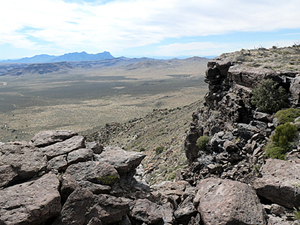
The edges of the mesa are quite abrupt. Looking down provided great views. |
We spent about an hour circumnavigating the plateau and sitting down for lunch under some pines. Looking down over the sharp edge was dramatic.
The views were wonderful including multi-colored Pinto Peak (which we four had climbed in 2021) and New York Mountain (which I climbed in 1996) to the north.
I hike a lot slower 30 years later, and Richard and I were each wearing knee braces! Our nine-hour climb was six and a half miles including a one-mile circumnavigation of the plateau. |
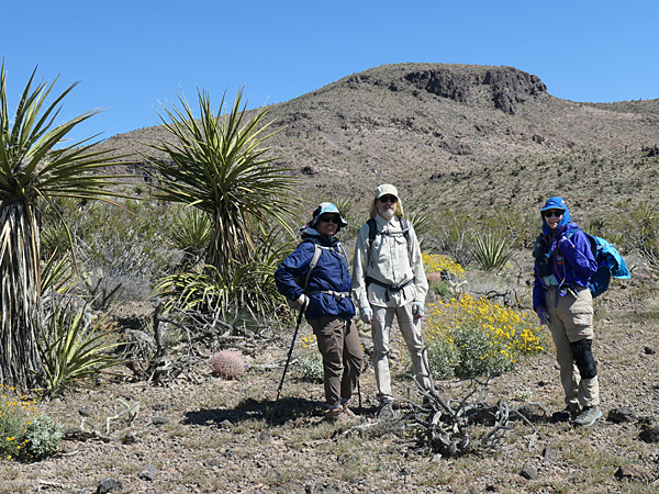 Tortoise Shell Mountain with Carmelita, Med, and Debbie in foreground. Acton Encelia (yellow flowers) behind. Tortoise Shell Mountain with Carmelita, Med, and Debbie in foreground. Acton Encelia (yellow flowers) behind.
Tortoise Shell Mountain, 4601'
March 6, 2026
by Debbie Bulger
photos by Richard Stover
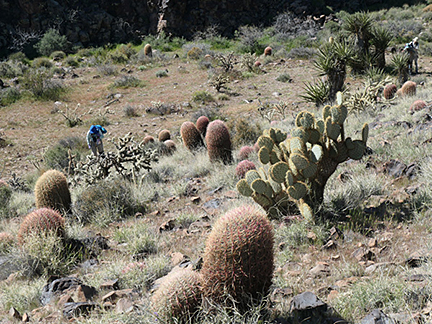
Richard Stover, Med, Carmelita and I climbed Tortoise Shell from our campsites at Hole-in-the-Wall Campground. It was cold when we started at 7:30 a.m. and getting chilly again when we returned eleven and a half hours and 11.4 miles later. Hey, we don’t just climb; we stop to look at the flowers.
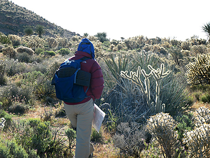
The start of the hike was an exercise in careful weaving as we threaded our way through a gauntlet of spiky vegetation: Several species of cholla, two types of yucca, and various other armed desert shrubs.
Once we gained Black Rock Wash the going was easy for over two miles as we walked south then east past the mouths of Rustler Canyon, Grass Canyon and Burro Canyon losing about 500 feet of elevation. We heard but did not see the burro which launched a raucous call. |
|
Careful walking was required at the start of the hike. You can tell it was cold. |
Once we reached the wash, the walking was easier. Tortoise Shell Mountain is not visible in this photo. |
After leaving the wash, we ambled uphill through a magnificent cactus garden. We were on the summit in time for lunch. |
|
Barrel Cactus, Pancake Pear (Opuntia) and Cholla dotted the hillside. |
Volcanic rocks littered the ground making walking more difficult in places. You can see the was in the distant background. |
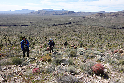
The wind on top was furious, likely 45 mph. So after signing the register, we dropped back down to the obsidian band just below the summit for a more sheltered spot for lunch.
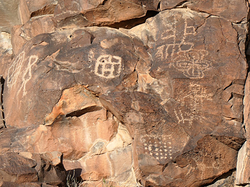
The flowers didn’t disappoint: Several species of Phacelia, both yellow and white Primrose, Mojave Aster, and more. We found three balloons making this a typical trip with some petroglyphs thrown in for good measure. |
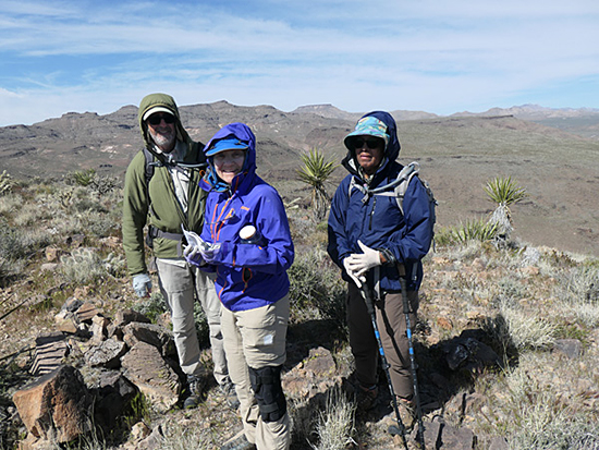 Med, Debbie, and Carmelita on the summit. To the north on the horizon is Table Top which we climbed two days before.. Med, Debbie, and Carmelita on the summit. To the north on the horizon is Table Top which we climbed two days before..
|
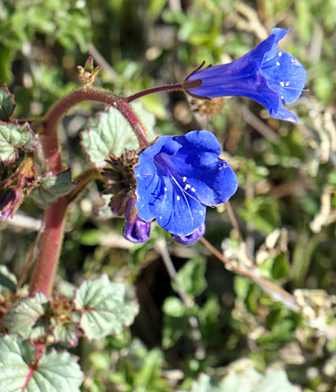 Desert Canterbury Bell
|
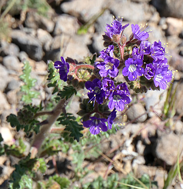 Notched-leaf Phacelia
|
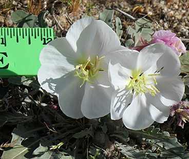 Evening Primrose
|
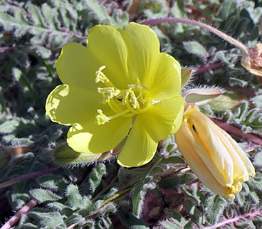 Yellow Desert Evening Primrose
|
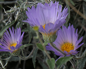 Mojave Aster
|
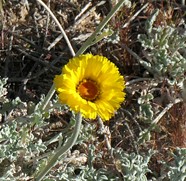 Desert Marigold
|
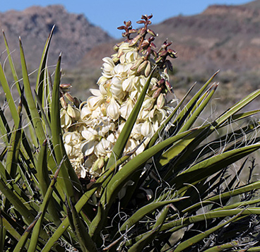 Mojave Yucca
|
 Balloon
|
|
It you know where to look, there is a lot to see.
As we returned at dusk, a Great Horned Owl flew by. |
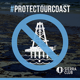
TELL TRUMP NO NEW OFFSHORE OIL DRILLING IN CALIFORNIA
Submit public comments to the Federal Register link here, before January 23, 2026.
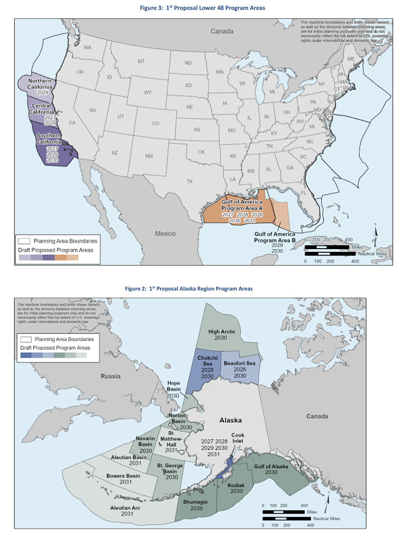
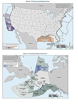
On November 20, the Department of the Interior released President Trump’s new offshore drilling lease plan, the 11th National OCS Oil and Gas Leasing Draft Proposed Program. The proposal includes as many as 34 potential offshore lease sales across 21 of 27 existing Outer Continental Shelf planning areas, covering approximately 1.27 billion acres. It includes 21 areas off the coast of Alaska, seven in the Gulf of America (GOA) including portions of the Eastern gulf (Program Area B), and six off of California.
California talking points. (Put in your own words.)
• Trump’s Offshore Drilling Plan places California’s invaluable ocean resources and coastal economies at risk.
• California's "ocean economy" employs nearly half a million people and generates over $44 billion in annual GDP. This includes tourism, recreation, fishing, and shipping. In contrast, the entire oil and gas extraction industry in California (both onshore and offshore) employs fewer than 25,000 people.
• Coastal tourism and recreation alone support over 430,000 jobs and contribute more than $40 billion to the state's economy annually. A single major oil spill could devastate this economic engine.
Click for full sized image
• Currently, more than 390 municipalities across the country have formally opposed the expansion of offshore oil and gas drilling activities, including over 90 along the Pacific coast.
• Many West Coast leaders vocally oppose expanded offshore oil drilling including California Governor Gavin Newson, Washington Governor Bob Ferguson, Oregon Governor Tina Kotek, the California Fish and Game Commission, the California State Lands Commission, and the California Coastal Commission.
• The U.S. Department of the Interior's own modeling shows that for any given year, there is a nearly 40% chance of a spill of 1,000 barrels or more occurring in the Pacific Outer Continental Shelf if leasing and drilling are expanded.
• The threat of another catastrophic spill like the 1969 Santa Barbara blowout is too great to risk California’s thriving coastal economies and healthy ocean resources. The 1969 Santa Barbara oil spill released over 3 million gallons of crude and devastated the local tourism industry. Beaches were closed for months, and the region's reputation as a pristine destination was severely damaged.
• A more recent 2015 pipeline spill near Santa Barbara leaked over 120,000 gallons of crude, contaminating popular beaches like Refugio State Beach. The economic impact was immediate: $74 million in estimated losses to the tourism and recreation sectors in Santa Barbara and Ventura counties and a 21% decrease in visitor spending in Santa Barbara in the month following the spill.
• Offshore platforms and support vessels are significant sources of air pollutants. A study by the Center for Biological Diversity found that existing offshore drilling in federal waters off California emits harmful pollutants equivalent to thousands of cars and heavy-duty trucks operating continuously. Exposure to volatile organic compounds, nitrogen oxide, and greenhouse gases emitted from offshore oil and gas operations is known to increase rates of asthma, cardiovascular disease, and cancers.
The Department of Interior’s 60-day public comment period is open from November 24, 2025 through January 23, 2026 through the proposal link published in the Federal Register.
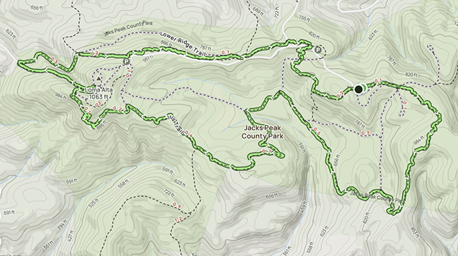
Review of Jacks Peak Hike
Also a bit about staying safe while hiking
by Ryan Trundle
Fall 2025
Some very lovely people, via our Meetup Group, recently joined me for a beautiful 6 mile hike around Jacks Peak. The park was named after David Jacks, a 19th century Scottish immigrant who acquired thousands of acres of land through questionable means from Native Americans, Mexicans and poor farmers. He would have fit well in this administration. That being said it makes my heart glad the land is publicly owned and free to enjoy. It doesn’t make much sense to me that if I hoarded more shoes than I could wear in a hundred lifetimes I would have an illness but if I hoarded more land or money than I could use in a hundred lifetimes I would be admired. Hoarding is hoarding. I am not saying that just because I like shoes. It’s ok to have a nest egg, it’s ok to have a couple dozen shoes, it’s very much not ok to have more money than entire nations while paying off politicians so you can hoard more money at the expense of those most in need. Sorry, that’s what happens when I watch the news.
Back to the trail. One would expect this trail would be so crowded reservations are required, the opposite is true. We were the only ones in the easternmost parking lot and didn’t see anyone until the end. The trail we chose was 6 miles with a thousand feet of gradual elevation. Some up and downs but no very steep ups. The whole trail winds you through Monterey Pines and Coastal Live Oak. We went clockwise through the forest catching glimpses of Seaside and Marina. The turn takes you south where thick forest opens up to wide views of Carmel Valley.
There is phone coverage the whole way if that’s something you worry about. Some people with medical conditions or social media addictions require this. Fortunately I have neither of these but do worry about others. Some phones now have satellite coverage by subscription or solely for emergency numbers. If you frequently travel beyond cell tower range you might consider a satellite communicator. I always have one hiking. They vary in price and function, mine was $150 plus another $25 a month for unlimited texting and weather checks. It has a SOS button for rescues and a “check in” button that when pressed sends your location to everyone you have added to a list with a preloaded “I’m ok” message. You can also connect it to your phone and text people back home in case you left the oven on or to tell them to bring in your shoe delivery. Some are more like a satellite phone and much more expensive. Some are only an emergency beacon and very inexpensive. I’m also certified in Wilderness First Aid, which isn’t like a Florence Nightingale Snow White mash up healing forest creatures as I had hoped but a high level First Aid for when help is hours away and your only resources are twigs and bandanas. Still useful I guess but whatever.
You are heading west now where it feels like the wilderness. No other people or buildings to be seen for a couple miles. Then bits of Carmel Valley come into view. Getting close to the west parking lot people start to appear, some have dogs with sweaters. I don’t know why. Your experience may vary. There are some wide open spaces here where you can see Carmel, Point Lobos and Fish Ranch. There is also a huge bench with a beautiful view that will fit 8 locals or 4 tourists. Keep going past the fossils and someone's back yard where you can see Monterey and Carmel at the same time to a steep downhill. I was a bit worried thinking about the climb back up but it’s much more gradual. Going counter clockwise would be a good workout. Heading back east is a gradual climb with views all the way to Santa Cruz and once again no people. The last half mile there are road crossings but no traffic. And we are back at the parking lot. Both parking lots I saw had clean bathrooms and water available. Puppies are allowed on the trail, just don’t be one of those people who bags the poop and leaves the bag on the trail. If you don’t want to carry it, get one of those dog backpacks and make them pack it out. It’s their mess anyway, maybe get a size larger so it fits over their sweater.
So I would very much recommend this trail if you like solitude, trees and views. It took us about two and a half hours plus a rest on the giant bench. Let me know if you want help choosing a satellite communicator or a trail or whatever;
Ryan Trundle
Andrew Molera State Park Review
Also, What’s the Deal With Hiking Sticks?
by Ryan Trundle
Late Summer 2025
When I daydream about hiking this is what it looks like. Breathtaking describes both the views and the climb.
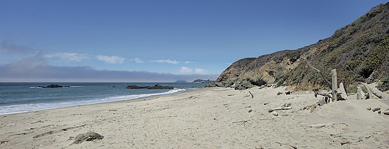
The hourish drive down was beautiful although littered with tourists. Once again I find myself wishing for nerf bumpers, especially around Bixby bridge. Traffic eases up past there. It was a sunny day so the parking lot was full of people heading to the beach north of the trail. They do charge for parking but have restrooms, water and a nature center.
Follow the passels of children and parents dragging giant coolers across the wooded walkway over the river down a wide road for half a mile. Turn left. The guide says the first two hills are fairly steep. I would like to dispute their definition of hills. You will go up, down, up and down again thinking that wasn’t so bad. That wasn’t the two hills though. It keeps going up for another mile. It’s more like two mountains with a bunch of little hills on them like a Stegasourus.
Thinking it might be difficult I got out my hiking sticks early. People seem to have mixed feelings about hiking sticks. Some people refuse to use them. I wore out most of my joints playing rugby for more than twenty years while generally treating my body like a rent car with full coverage so I very much appreciate them. Uphill it’s a great workout for arms while keeping knees from screaming so loud. Downhill they keep my weak brakes in check. Going across rivers on slippery rocks it’s like having four wheel drive, I haven’t fallen in since I started using them. Most long distance hikers use them as well no matter their age. They aren’t indispensable but sure do come in handy, kind of like sneaking a six pack of beer into your friend's pack.
Make sure you stop a couple times on the way up and turn around. The view is incredible. Towards the top of the second mountain there is a nice bit of Redwoods. A little ways on the other side of the top is miles of coastline to the south. The day I went it was foggy five miles south of the trail, five miles west and five miles north. The trail down is hard only in the sense that the ruts are deep and you are too busy gawking at the view to pay attention to your footing so stumbling is frequent. Fortunately my hiking sticks saved me from wiping out.
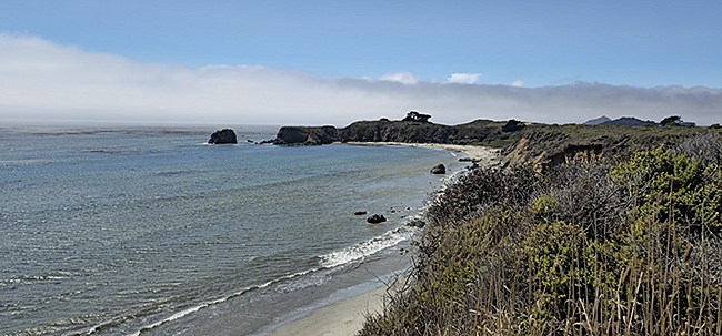
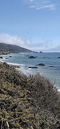
Half a mile going north along the coast turn left, over a pile of driftwood and onto your own private beach. There was no one when I got there, no one while I ate my lunch and no one when I left. It was a travel magazine cover amazing with white sand, waves crashing and small puffs of fog floating by.
I could have stayed for days but only brought one sandwich. The last mile hugs the coast line until you see the beach everyone went to. It actually looks like a fun little protected cove for paddle boarding and what not.
That’s it. Highly recommend this hike. If the hills (aka giant mountain) is too much for you, do an up and back of the coastline and visit the beach. Until next time! Also don’t forget to follow us on Meetup for group hikes https://www.meetup.com/sierra-club-ventana-chapter/ If you have any questions or suggestions for future hikes send me an email at
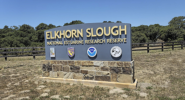
Elkhorn Slough Review
AKA Elkhorn Slough National Estuarine Research Reserve
Also a bit about shoes
by Ryan Trundle
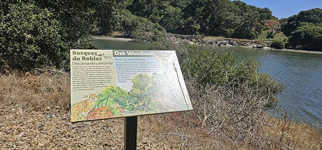
This may be the best one-size-fits-all hikes around. Do you like birds? Got thousands, especially during migrations. Do you like sea otters? Yep. Sea lions? Sometimes. Great huge views where you can see for miles? That too. Flowers, trees, and wide open spaces? Plenty! Really smart and nice people there who tell you all about what you see? That too. Long trails, short trails, bridges, and an island? Of course.
Contrary to my usual method of trying to google flora and fauna I see on my hikes with zero bars we took an opportunity to hike around the research reserve with a docent who is like your own Elkhorn Slough Wikipedia but with a great personality. They have guided hikes with a naturalist every Saturday and Sunday at 10 AM and 11 AM. More information can be found here https://elkhornslough.org/reserve/.
You can find the Elkhorn Slough National Estuarine Research Reserve conveniently located halfway between Monterey and Santa Cruz on Elkhorn road. There is no charge for parking. There are restrooms and water available. Be sure to check out the nature center at the beginning, it is full of interesting displays. They also have information displays on trail,
Our Docent (who was amazing!) led hike went counter clockwise while they pointed out the incredibly diverse flora and fauna. Unusually I go clockwise while turning left at every intersection, turn left twice at the dead ends. If you walk every foot of every trail you might travel six miles. Total elevation change is around 250 feet.
The south loop with two offshoots leads you around a couple large ponds, or maybe small lakes full of pelicans, egrets and herons. Small hills with oak trees scattered about grassland make up the rest. Be sure you go out to Parsons Slough Overlook for a nice panorama. Heading back north winds you down to the wetlands. There is a walkway that takes you over the water.
Follow the trail over another bridge then turn left to the island. Watch out for trains and the young sea lion that has been hanging out around the oyster beds. The island has a nice bench right on the slough with a great view of kayakers. It would be quite easy just to stay there watching the hundreds of birds but you have a couple miles to go and the park closes at 5. Back across the railroad tracks turn left, up the hill to a nice viewpoint. Give me a wave, I can see it from my house.
A left turn takes you past ponds full of ducks. They are usually very busy doing duck things while chatting to each other the whole time. The wide path leads you in the shade of oak trees past a few more ponds and back to the parking lot. Here is the Alltrails map I made. Elkhorn Slough Map at AllTrails
I have a list of the most asked hiking questions and will try to answer them all eventually. The top one was what shoes to wear. Full disclosure, I might have a slight shoe hoarding problem. I may also tend to check what other people are wearing. The best place for shoe watching is Point Lobos. You will see everything from flip-flops to shiny high heels to crampon ready mountaineering boots. So what shoes are best for you? There are thousands of choices. My feet are flat and wide like Fred Flintstone so I like Altra and Topo Athletic shoes. According to a website that does long distance trail surveys, halfwayanywhere.com, the ten most popular trail footwears on the PCT were all trail runners. They are light and super comfortable. I also go through at least three pairs a year as they are not super durable. The softer sole grips better but wears faster. A hiking boot can last decades with resoling but take a year to break in and feel like cement on a cold day. Whatever you get, make sure they are comfortable with a good tread. Don’t think about it too much. It’s fun to get the newest gear but not necessary. There was a 67 year old woman, Emma Gatewood, who hiked the Appalachian Trail wearing a pair of Keds and carried everything in a denim sack. Her shelter was a shower curtain.
If you haven’t yet, follow us on Meetup for hikes and whatnot. Remember the important part is getting out there even if all you have is a shower curtain and Keds.
How far can you hike?
And review of the Fort Ord Mudhen Lake and Rim Trail Ramble
by Ryan Trundle
The Mudhen Lake and Rim Trail Ramble at the Fort Ord National Monument is a 14.5 mile loop, technically a quadruple loop, that took me a little more than 6 hours to complete. I tend to stop to look around a lot. There was also a lunch break. It was moderately difficult for me. A blue run you might say. Not much elevation change but a nice stretch. I use Alltrails, here is the link. Mudhen Lake and Rim Trail Ramble. I am sure there are a few apps that are as good. I use it to know how fast I’m going and it alerts me when I miss a turn being too busy looking at the views to notice the trail markers. It isn’t very hard to take a wrong turn at Fort Ord either. The trails map looks like a smashed windshield labeled with random unsequential numbers. On the bright side if you miss a turn just take the next one.

The trailhead is clearly marked with limited parking. No water or restrooms so get and go before you go and git. The first mile or so parallels a road with intermittent subdivisions. It was a bit foggy in the beginning walking through low oak trees covered in Spanish Moss. Fortunately a mountain biker hit the trail before me and took care of the spider webs. Past some empty ponds, a couple old army buildings and some very nice goats the sun came out and terrain opened up.
There were a few mountain bikers on the trail but they were polite. If you don’t know they will alert you when coming from behind with a “On your left”. If you feel like an uninvited handlebar ride move left, to get out of the way move right. Legally hikers have the right of way but I don’t quite get that, it’s much easier for hikers to step out of the way so I do. Hikers and bikers are supposed to yield to horses which I get. I don’t know who horses yield to, maybe Llamas?
The next few miles climb up a bit through sparser trees and eventually hilly scrubs. Wide open spaces with great views of Salinas and Simas peak. Up and down little hills with twists and banked turns. The trail map has you doing a double figure eight but I just went clockwise.
Given a choice I like getting most of the elevation gains in the beginning of the hike and downhill at the end. That’s what my knees tell me anyway. Really steep trails in either direction hurt. I played rugby for more than 20 years breaking, spraining or tearing just about every part of me. Luckily the multiple concussions let me forget that when I’m planning a hike. Taking my body on a hike is like taking a demolition derby car on a road trip. The brakes don’t work, the engine barely goes and the whole thing sounds like it’s falling apart. You’re not sure if you will make the trip but at least you aren’t worried about a few more dents. Also in a pinch it will run on alcohol. So far I haven’t had to be towed back home so there is that. I can go about 25 miles on a good day, sometimes I turn around after just a few miles. Sometimes I pass people, sometimes I get passed. When you are figuring out your fitness level all that matters is you get where you want to go. Optimally you also want to be able to walk the next day as well.
It’s not a race. It’s not a marathon. It’s walking around and looking at things.
My pack is too heavy, my belly is too big, and I wear swim shorts hiking but I get out there and have a great time. I don’t worry about anything but that last part. The only fitness level I make sure to know is when I am at half of how far I can go that day. If you know that you will always make it back to the car.
Back on to the trail on the back end of the trail there are a couple of perfect ponds full of ducks and maybe a couple geese. There is a bit of up and down but not too bad. Most of it is a nice narrow trail. There are some dirt roads and a small amount of regular road. The changes and scenery keep it interesting. The last section are Savana like fields before you get back into the thicket of short oak trees. That’s about when you start to see people again.
All things considered it’s a really nice place to wander around looking at stuff with many completely different ecosystems.
I think we will do this hike again soon. We are posting group hikes here https://www.meetup.com/sierra-club-ventana-chapter/ It’s free to join. If there are any outings you would like to see or any questions feel free to email me
.
Remember, it’s not a race. It’s not a marathon. It’s walking around and looking at things. Hike your own hike and have fun out there.
Ryan Trundle
Where to thaw out?
by Ryan Trundle
Welcome to my second article. Hopefully you enjoyed the last one enough to not run away from this one.
Like many of you I spend most of my summers in an ethereal polar bear plunge. I am talking about the June gloom gaseous ice bath fog that tends to overstay its welcome by a couple months. Most of the time I appreciate the beauty of it but eventually my memory of the miserableness of sweltering in blistering heat has faded enough I want to go hike somewhere warm. That is what happened to me Sunday after spending Saturday shivering. Ironically I woke up to sunshine Sunday.

Anyway I decided to visit Stevens Creek County Park and hike the Canyon Trail. Just an hour's drive from Elkhorn Slough in Cupertino. I usually try and find a nice local place for breakfast but woke up too late for that this time. Breakfast recommendations are always welcome. G-Maps led me there without incident as it’s not far off the beaten path. The only issues on the road were dozens of middle aged men in spandex fighting for the Lanterne Rouge. More power to them but sometimes I wish they made nerf bumpers. I stopped at the first parking lot and paid the $6 fee twice. It's a credit card only machine which another hiker did not have so I gave them mine. Just past the first parking lot there is a little building with a fountain for water in case you forgot to fill your tanks.
The trail itself starts out pretty easy, I did’t get out my hiking sticks the whole time so I would rate it moderate although the heat added a level of difficulty towards the end. The Alltrails app claimed I went seven miles while my phone's pedometer said I went 8.2. Split the difference and call it 8 even. It took me about 3.5 hours going clockwise.
Dogs may be required or issued at the entrance. They must have ran out before I arrived because everyone else had one but me. I said “Hello, pretty puppy!” 37 times in 3.5 hours. In Louisiana my eldest daughter and I went on a hike co-sponsored by the SPCA and everyone actually did get a dog. I would love to do that here so if you have a shelter contact up let me know please.
Be sure to pay attention to the signs. This one warns of giving fish cutlery. |
|
This one advises you not to go swimming with your bicycle. |
The first couple miles follow the reservoir and are nicely shaded. The water was bluer than the Caribbean.
This was around noon and the temperature was still in the lower 80s. There still were plenty of people to talk to and puppies to pet. Around mile 2 our trail takes a left turn and the uphill begins. And up and up and up. It’s a nice grade though, not too steep like some of these around here. There are a few local “trails” here I am certain were originally meant for only donkeys and pack mules.
The next couple miles wound their way through the trees with a few exposed areas. Nice views here and there. At the halfway point there is another parking lot, picnic table, bathroom and water spigot. Maybe be a nice lunch break spot, you could even have pizza delivered.
Half a mile past that the trees go away and the temperature rises exponentially. I can actually hear my Irish skin sizzling. Bug spray or netting isn’t a bad idea in this part. Little face flies ride the dust up your nose. You might consider running back to the cool water of the reservoir at this point but that would be a mistake. In just another apocalyptic hell fire half mile I made to the top where you can see from Gilroy to downtown San Francisco. It is totally worth the 8th degree sunburn. I don’t have a picture that does it justice so we’ll just leave that up to your imagination.
A bit of downhill and you are back at your car and I am at the end of this review. I would for sure hike this again maybe in the fall which brings me to the announcement. We have a Meetup group and an Instagram page. Please join! The Meetup name is Sierra Club Ventana Chapter of course. The Instagram is @centralcoasthiker831. There is nothing on them yet so it’s the perfect time to join, follow them. I am also about to post our first outing on Meetup which will be a tour of an amazing, wildlife filled, local trail system guided by one of their brilliant staff.
What outings would you like? Let me know.
TTFN,
Ryan Trundle
 Mount Bago as seen from Kearsarge Pass. Bullfrog Lake is in the center of the photo. Mount Bago as seen from Kearsarge Pass. Bullfrog Lake is in the center of the photo.
Mt. Bago, 11,870'
July 1-6, 2025
by Debbie Bulger
photos by Richard Stover
The view from the top of Mt. Bago is one of the finest in the Sierra. Climbing Bago is considered “easy” by peak bagger standards, but somehow becomes harder the older one gets. The easiest way to get there is to surmount Kearsarge Pass which at 11,760 feet is almost as high as Mt. Bago. One then drops about 1,400 feet to Charlotte Lake.
Starting from the Onion Valley Trailhead at 9,100 feet, Richard Stover and I hiked the 4.7 miles to the the pass. We had camped at Onion Valley for two nights to acclimatize and hiked the 4 miles round trip to Robinson Lake as a warm up the day before.
The flowers were in their full glory, especially in the wet areas around creeks and seeps. We spotted leopard lilies, rock fringe, Labrador tea, shooting star, rein orchids, various penstemon, mountain pennyroyal, cinquefoil, various buckwheat, and many more. Quite a show. I always feel exhilarated when surrounded by mountains and native plants.
 Rock Fringe. Rock Fringe.
The pass was cold and windy.
We dropped to one of the Kearsarge Lakes on the west side and barely had time to set up camp before dark. Our neighbors were a mother Sooty Grouse and her chicks. |
|
 Labrador Tea Labrador Tea
|
 Debbie and Richard at Kearsarge Pass. This was the 6th time I have gone over this pass on the way to various peaks.. Debbie and Richard at Kearsarge Pass. This was the 6th time I have gone over this pass on the way to various peaks..
The next day we passed spectacular Bullfrog Lake (no camping allowed) and found our way to the junction of the Charlotte Lake trail with the PCT where there was a very nice view of the route up Bago. |
 Mom Grouse Mom Grouse
|
 One of the Grouse chicks One of the Grouse chicks
|
 Looking south from Bullfrog Lake.
|
|
 Note the red rock on the lower summit of Mt. Bago. Close-ups in photos below. Actual summit is to the left of the red rock.
|
 Debbie at south shore of Charlotte Lake. Debbie at south shore of Charlotte Lake.
The clouds were building, the temperature dropping, and we had just gotten our tent up at Charlotte Lake when the sky let loose. There was snow and hail in addition to the rain. The zipper on our well-used tent wasn’t closing and in our haste, we had not tucked the ground cloth under the tent allowing water to flow between the tent and the footprint.
By the next morning the rain had stopped, the ground was covered with frost, and we spent a few hours drying out our wet tent, sleeping pads and gear. We were ready for a layover day.
Finally on day four we headed for the summit of Bago. The route is straightforward: Up the nose of the lower summit, cross the saddle and then up the higher summit. |
|
 Approaching red rock on way up. Snow cornice and true summit beyond to the left. Approaching red rock on way up. Snow cornice and true summit beyond to the left.
|
|
 Debbie approaching saddle between lower and upper summits Debbie approaching saddle between lower and upper summits
|
There was a snow cornice between the two summits, and we were hoping to find some “watermelon” snow there (pink snow colored by bacteria). We had brought a sampling kit sent to us by a researcher and collected two samples in a bit more than an hour.
 Richard collecting snow sample from cornice in saddle.. Richard collecting snow sample from cornice in saddle..
|
|
 Richard and Debbie on summit of Mt. Bago. Richard and Debbie on summit of Mt. Bago.
Then we were on the summit where we spent another hour. The view was very special. |
 What a view!
Reversing our route was harder than climbing up as the rock was crumbly and parts were steep.
We returned to camp at a leisurely pace by 6 p.m.—12 hours after our start. These old climbers needed a layover day to rest up after the climb.
The next day we hiked all the way back to the trailhead, taking photos of more of the residents of this mountain wilderness. Of special note were the group of six bachelor bucks waiting their turn in the coming years to challenge the alpha male.
|
|
 Richard descending
|
 One of the young gentlemen we saw on the hike back to the trailhead.
|
 Belding's Ground Squirrel |
 Golden-mantled ground squirrel |
On the way back to the pass we noticed that the backside of some of the official signs had been decorated with a green sticker with an illustration of a pile of rocks (cairn or duck) which purported to be from NACA, the North American Cairn Association with the slogan, “False sense of hope since 1848.” !!! As a die-hard duck buster, I had a good chuckle.
|
|
 Debbie almost back to Kearsarge Pass. |
 Ryan Trundle at the Santa Cruz No Kings protest. Ryan Trundle at the Santa Cruz No Kings protest.
Ok, I Protested. Now What?
by Ryan Trundle
Is anyone else thinking the same thing? Is it weird to begin an article with so many questions?
Who is this guy asking all the questions anyway?
Well, that is me at the Santa Cruz No Kings protest. My name is Ryan and I am the newest member of the Sierra Club Ventana Chapters executive committee. I am very excited to also be the Outings Chair. Basically I get to go on a lot of fun hikes but I have to go to meetings as well. C’est la vie.
I have a lot of plans for fun get togethers, hikes, camping, kayaking, gear testing, social media, community building and the like. One idea our phenomenal executive chair Rita had was to write a weekly article for our website. Considering my last creative writing class was decades ago it might be more of a weekly rambling blog. Hopefully entertaining though. If there is anything you all would like to know about please let me know. Contact info below.
So this is part of my “Now What?" Protesting is great and really does make a difference but, at least for me, there is always that feeling that that wasn’t enough. Maybe it is due to growing up in an instant gratification generation but I half expect we would go protest, politicians would say “Oops, sorry” and everything would go back to normal. Unfortunately that only happens in France. We have to go home, put away our signs and figure something else to do before we get fed up and move to France.
Sometimes it is just too overwhelming with the amount of absolute idiocracy the Mango Mussolini spews forth. I read that included in the big budget busting billionaire benefits bill was funding for ICE that is more than the Russians' entire military. $170 billion vs $140 billion respectively. Yet we can’t afford universal health care or school lunches or even schools. It will boggle even the slightly empathetic mind. The first rule of living through this dystopian delegation is take care of yourself first. That is also what they taught us in the wilderness first aid class I took recently. First, make sure you are safe. You can’t help anyone else if you’re a mess as well. In life that might equate to going for a hike, hanging out with friends, going out to dinner or not getting out of bed all day, gorging yourself on Uber eats while binge shopping online, and trying to find something you haven’t seen on Netflix. Whatever it is, do it. Recharge those batteries, get your chi in line, and get your brain as right as it can possibly be while realizing brains are silly messy things to begin with and never really right. Don’t worry about what others will think as we have all been there and totally get it.
Step number two sometimes overlaps with step number one. Find something productive to do. For myself, the only way to combat helplessness is to be helpful. So here I am with the Sierra Club. I also took the training and try to help with the Solidarity Network. In the past I have organized direct actions, clothing drives, shelter dinners, campaigns, and many other things I might talk about in another rambling blog (ramblog? blogbling?). The point is getting out there and doing anything positive. Or if you can’t get out there being a keyboard warrior or ninja letter writer has an enormous impact. Maybe put that green thumb to use in a community garden. The protests always need people to help if that’s what you like. For our chapter, SCVC, we need help with leading outings, social media, community outreach, collaborations, and maybe a writing tutor. Let us know, we will find something you will enjoy. It’s ok to try different things too, you don’t know until you try.

Step three. Pat yourself on the back and give yourself a cookie, seriously. You are awesome! You are doing more than most anyone else and that is something to be proud of. I want to personally thank each and every one of you. “Unless someone like you cares a whole awful lot, nothing is going to get better. It's not." But you do care and it is going to get better. “It's not about what it is, it's about what it can become.” I know if we work together we can replace the lummox with a Lorax.
That’s it, my three step plan for the Now Whats. Sometimes I do step one too much and am very bad at step three but to quote Michelangelo at 87 "Ancora imparo," and still, I am learning.
Have a great week!
Ryan Trundle
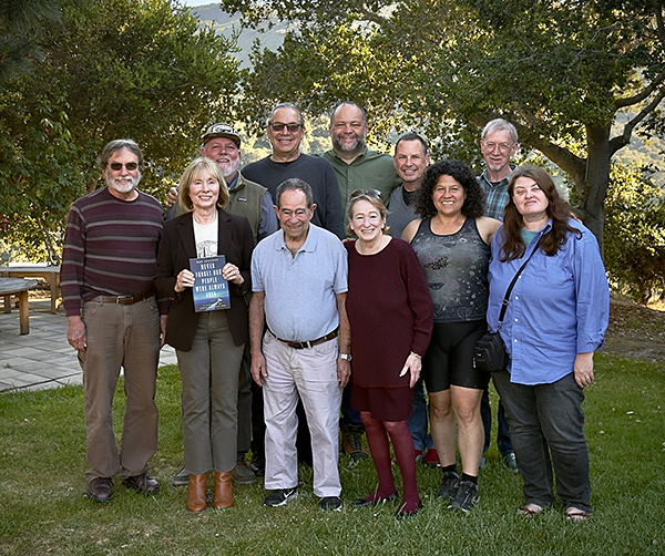
Chapter and Santa Cruz Group members met with National Sierra Club Executive Director Ben Jealous (back row center) in Monterey on May 8. Shown here are Joel Weinstein, Chapter chair and his wife Bonni, Chapter conservation chair Rita Dalessio, Group Chair Mike Guth, Chapter political compliance officer, Steve Leonard, Chapter outings leader Ryan Trundle, Group outings leader Steve Bakaley, Group conservation chair Kristen Sandel, Group transportation chair Lani Faulkner and Sierra Club staff Mike Parrish.
Welcome Our New Director, Miguel Miguel!
by Michael Blenner
Please welcome our new Director Miguel Miguel (he/him) to Sierra Club California! Miguel joined us this month from Pacoima Beautiful, a grassroots environmental justice organization that provides education, impacts local policy, and supports local arts and culture in order to promote a healthy and sustainable San Fernando Valley.
As Director, Miguel will supervise all Sierra Club California staff, and be responsible for the strength, functioning, and growth of Sierra Club California and the impact of the organization’s work across the state. He will work alongside the Sierra Club California Executive Committee, our network of 13 local chapters across the state, and staff across the organization to grow our base of member support, design and execute effective campaigns, engage donors, and achieve our organizational priorities in the state legislature and at state agencies.
You can read Miguel’s full bio below. Stay tuned for Miguel’s first Letter from Sacramento later this month, and upcoming communications from him on our legislative and advocacy campaigns.
Miguel Miguel Bio
Miguel Miguel joined Sierra Club California as Director in April 2025. He leads the organization’s operations, political strategy and advocacy work across the state. Prior to Sierra Club, Miguel served as the Policy Director for Pacoima Beautiful focused on fighting for environmental policies in the communities he calls his home. Miguel is born and raised in Los Angeles, and has worked in the environmental world for nearly a decade across multiple issue areas. He first started his career as a geologist working alongside tribal nations and archeologists preserving cultural resources. Miguel later worked for the City of Los Angeles and the University of California Los Angeles while pursuing his masters in Urban and Regional Planning.
 Amboy Crater is definitely worth a visit. There is a trail to the rim of the crater. Amboy Crater is definitely worth a visit. There is a trail to the rim of the crater.
Lane Mountain, 4,522'
Amboy Crater trail building
February 14-16, 2024
by Debbie Bulger
photos by Richard Stover
Richard Stover and I were on our way to help build a trail at the Amboy Crater National Natural Landmark in the Mojave Desert about an hour east of Barstow, CA. This black cinder cone towers 250 feet above the surrounding lava field.
The volunteer work was a joint project between the Sierra Club and the Bureau of Land Management office (BLM) out of Needles, CA.
Since heavy rain and flooding were predicted for Santa Cruz, Richard and I left early to beat the weather. As a result we had time for the short, windy climb of Lane Mountain.
 Lane Mountain rises in an open Joshua Tree forest north of Barstow. Lane Mountain rises in an open Joshua Tree forest north of Barstow.
We drove to the base of the peak on a dirt road north of Barstow and walked about a mile up the once paved road to the summit. |
|
|
|
 The approximately 2-mile walk up the road and back took us an hour and a quarter.
The edges of the deteriorating road were lined with dried chia flowers from last year, a hint of the color soon to come. |
 Last year's chia flowers had already scattered their seeds.
|
 You can tell it was very windy by looking at my hat.
|
 Volunteers and some BLM staff working on the new trail at Amboy Crater. |
On top 50mph winds plastered me against the chain link fence surrounding the communications facility.
Late afternoon saw us at the Amboy Crater where we met up with other volunteers for two days of trail building, camaraderie and clean up. The young and strong were equipped with crow bars and shovels to move rocks. The rest of us lined the pathway with rocks to demarcate the trail or used rakes to move smaller lava pieces and stones. Others followed with brooms to erase our footprints. |
|
 Volunteers line the trail with rocks.
Among the lava rocks we saw a new-to-us desert beetle later identified as Edrotes ventricosus. These ball-bearing sized creatures look like fuzzy jack rabbit droppings scurrying through the sand. Learn something on every trip! |
 This beetle is only the size of a ball bearing. |
With camera in hand, Richard documented the beetles and got a bonus view of a Long-tailed Brush Lizard. The tails of these approximately two-inch lizards can be twice as long as their bodies. |
|
 A Long-tailed brush lizard.
|
|
30x30 starts 2025 with monumental gains
February, 2025
Sierra Club's California’s campaign to conserve 30 percent of our lands and waters by 2030– with the goals of protecting biodiversity, stabilizing the climate, and improving equitable access to nature for everyone– began the year 2025 with a bang! A grand victory was the proclamation in the final weeks of the Biden Administration of two brand new, large, landscape-scale California national monuments, together amounting to nearly a million acres of land conserved.
In the far north, a broad coalition of partners successfully advocated for the Sáttítla Highlands National Monument: 224,000 acres of national forest land in the Medicine Lake Highlands east of Mount Shasta in Siskiyou and Modoc counties near the California-Oregon border. The Pit River Tribe and also the Modoc Tribe spearheaded the campaign to protect the Highlands’ volcanically formed aquifers that send pure water far south and to protect their ancestral homelands from geothermal energy development.
And in far southeast California, the Chuckwalla National Monument was proclaimed to protect a 624,000-acre area of mostly Bureau of Land Management lands in the desert south of Joshua Tree National Park, extending east to the Arizona border. The Monument was sought by the Quechan Tribe, and the proclamation provides for Tribal stewardship. Senator Alex Padilla and Congressman Raul Ruiz had introduced bills in the 118th Congress for this monument, and when Congress did not act, they urged President Biden to use his power under the Antiquities Act.
Not all the area in the Chuckwalla National Monument is new protection for 30x30 purposes. Inside the new monument are five wilderness areas, established in 1994– Chuckwalla Mountains, Little Chuckwalla Mountains, Mecca Hills, Orocopia Mountains and the Palo Verde Mountains. But by giving connectivity to these existing separate wilderness areas, the new monument increases their habitat value.
Although the outgoing president did not have time to designate the Kw’tsán national monument in far southern California- another tribally-led California proposal– the Ft. Yuma Quechan Tribe did secure a co-stewardship agreement with the Bureau of Land Management for the Quechan Ancestral Landscapes area of traditional Tribal lands within the proposed monument boundaries. And the campaign for eventual monument status continues.
As we celebrate our monumental new protected lands, we remain on the alert against potential federal attacks. Stay tuned in this newsletter for ways to engage on 30x30 with the Sierra Club’s statewide task force. To find out which of your Chapter’s conservation efforts contribute to the state’s 30x30 goals, and how you can be part of the campaign in the Ventana Chapter, contact Vicky Hoover
().
--Vicky Hoover, Co-chair CA 30x30 task force
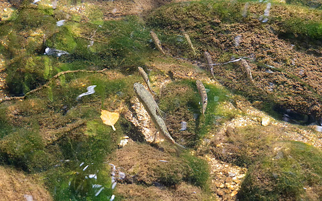
Volunteer Trout Wranglers Save Central California’s Steelhead
Saving an iconic species is as easy as moving them from one place to another
October 11, 2024
by Katherine Irving
from Sierra: The Magazine of the Sierra Club
 A CRSA volunteer prepares to take a tissue sample from a rescued steelhead trout. These tissue samples will go to scientists researching the genetics of steelhead and rainbow trout. | Photo by Paz Gur Arye A CRSA volunteer prepares to take a tissue sample from a rescued steelhead trout. These tissue samples will go to scientists researching the genetics of steelhead and rainbow trout. | Photo by Paz Gur Arye
Brian LeNeve doesn’t have much patience for people who are late. As he and a crew of five volunteers gathered in a small dirt parking lot at Garland Regional Park in the Carmel River Valley of central California, the 81-year-old seemed distracted by his watch, checking it between conversations. “We give people a 10-minute grace period before we leave,” he explained. Any longer than that, “we’re taking time away from the fish.”
LeNeve is the former president and current treasurer, conservation chair, and board member of the Carmel River Steelhead Association (CRSA), based in Monterey, California. The organization has one simple mission: Save the federally threatened South Central California Coast population of steelhead trout.
Genetically the same species as the rainbow trout, steelhead are characterized by one key difference: Unlike their freshwater counterparts, these fish spend most of their adult life in the ocean, only returning to the river where they were born to spawn. “It’s amazing to think that these fish that swim as far as Alaska come back to people’s backyards in central California,” said Eric Palkovacs, a fisheries ecologist at the University of California, Santa Cruz.
Why some fish become steelhead and others become rainbows depends on a myriad of factors. According to Palkovacs, every fish that eventually becomes a steelhead has a specific genetic mutation. But rainbow trout can have this mutation too, and they both can occupy the same streams. Whether trout with the steelhead mutation journey to the ocean can be influenced by nongenetic factors such as body size, weight, and gender. To simplify things, scientists designate populations with access to the ocean as steelhead and populations that are cut off from the ocean as rainbow trout.
Unlike steelhead, rainbow trout are not a threatened species. However, because all the fish in the Carmel River have access to the ocean, federal officials classify them as steelhead regardless of whether they make the journey or not. Unfortunately, they are in dire straits.
Due to the excessive pumping of the river for municipal water, parts of the Carmel River that once brimmed with life dry up every summer. When the river dries, young steelhead become trapped and die by the thousands from suffocation, heat, or lack of water. California steelhead populations are already threatened by dams, invasive predators like catfish and bass, agriculture, and more. Without intervention, a Carmel River die-off could lead to the end of this subspecies.
In order to avert that catastrophic outcome, LeNeve and his team take matters into their own hands, literally. Every year starting in July, organizers and volunteers go out to the upper part of the river several times a week to rescue fish, a process that entails catching trapped fish and moving them to parts of the river that continue to flow. The rescues continue until September, when the heat dies down and the river stabilizes.
Read full article here.
Biden-Harris Administration, NOAA designate 3rd-largest national marine sanctuary
Chumash Heritage National Marine Sanctuary to be managed with tribal,
Indigenous community involvement
October 11, 2024
from The National Oceanic and Atmospheric Administration
 Aerial view of Government Point, located within Point Conception State Marine Reserve and Chumash Heritage National Marine Sanctuary. This marine protected area contains kelp forests, surfgrass beds, and rocky reefs surrounded by sandy seafloor. It also hosts an abundance of diverse fish, invertebrates, birds, and marine mammals. (Image credit: NOAA) Aerial view of Government Point, located within Point Conception State Marine Reserve and Chumash Heritage National Marine Sanctuary. This marine protected area contains kelp forests, surfgrass beds, and rocky reefs surrounded by sandy seafloor. It also hosts an abundance of diverse fish, invertebrates, birds, and marine mammals. (Image credit: NOAA)
Today, the Biden-Harris Administration announced that NOAA is designating 4,543 square miles of coastal and offshore waters along 116 miles of California’s central coast as America’s 17th national marine sanctuary. Chumash Heritage National Marine Sanctuary will conserve the area’s diverse range of marine life and celebrate Indigenous peoples’ connections to the region. It is the third largest sanctuary in the National Marine Sanctuary System.
The sanctuary designation advances President Biden’s ocean conservation legacy and his America the Beautiful Initiative, which supports locally-led collaborative conservation efforts across the country and sets a national goal of protecting, conserving and restoring at least 30% of U.S. lands and waters by 2030. With this designation, the Biden-Harris Administration has now conserved more than 45 million acres of lands and waters.
“This historic Chumash Heritage National Marine Sanctuary designation, made possible thanks to President Biden’s America the Beautiful Initiative, will help provide critical environmental protections and allow tribal and Indigenous community management of the new sanctuary,” said U.S. Secretary of Commerce Gina Raimondo. “This milestone in our commitment to Indigenous communities and natural lands will boost recreation, tourism and other local industries along California’s central coast.”
“The Chumash Heritage National Marine Sanctuary is the result of state, territorial, local and Indigenous leaders partnering with the Biden-Harris Administration to show that we can protect culturally and ecologically important waters while building a clean energy future,” said Brenda Mallory, Chair of the White House Council on Environmental Quality. “With today’s announcement, President Biden has now conserved more than 45 million acres of lands and waters while protecting sites that honor Indigenous communities and tell a fuller story of our nation.”
Stretching from just south of Diablo Canyon Power Plant in San Luis Obispo County to the Gaviota Coast in Santa Barbara County, the sanctuary will bring comprehensive community- and ecosystem-based management to nationally significant natural, historical, archeological and cultural resources — including kelp forests, rocky reefs, sandy beaches, underwater mountains and more than 200 NOAA-documented shipwrecks.
Read full article here.
To Fulfill America’s Promise, Let’s Throw Everything We’ve Got at the Climate Crisis
It’s time to declare independence from fossil fuels
July 4, 2024
by Ben Jealous
from Sierra: The Magazine of the Sierra Club
 Activists gather near the US Capitol as part of a global climate strike to demand government action on climate change. | Photo by Matthew Rodier/Sipa via AP Activists gather near the US Capitol as part of a global climate strike to demand government action on climate change. | Photo by Matthew Rodier/Sipa via AP
Independence Day at its best is a call to action to leave our children an America as good as its promise.
This time of the year makes me think about my family’s journey in this country. My father’s family is white. He descends from the youngest combatant at the Battle of Lexington and Concord. My mother’s family is Black. She descends from two Black Virginia statesmen who helped to rebuild the Commonwealth after the Civil War. One of them descended from Thomas Jefferson’s grandmother.
Today, both sides of the family, like many Americans, live at or near some version of the same address: a place where there used to be factories, a place where when those factories shut down, what shot up was poverty, despair, suicide, and opiate addiction. And as if all that were not enough to deal with, it keeps getting hotter. The floods come more often. The super storms do as well.
If there is a silver lining in all this struggle, it is this: There is one solution that can tackle all these problems, and that is throwing everything we’ve got at stopping the climate crisis. If we do that, we will turn around the economy, our neighbors’ lives, and the fate of the planet itself.
The next five years will define who leads the world economy, the United States or China. Our leadership in innovation and design allowed us to take an early lead in the areas of electric vehicles (EVs) and other green technologies. But China leads in manufacturing. Today it dominates solar panel production and has overtaken the US on EVs as well. Still, we have not given up the fight, despite calls from Fox News and others for us to do just that.
Georgia is home to the largest solar panel production facility in the western hemisphere. The same company that owns that massive solar facility, Qcells, is about to open another one in Georgia that will be the only plant outside of China producing every component of solar panels, from ingot to finished product. This has been revolutionary in places like Dalton, the location of Qcells’ existing Georgia plant. There, a wall is decorated with the artwork of employees’ children showing their parents as heroes saving the planet.
Tennessee, North Carolina, and other Southern states have a battery belt. EVs are rolling off the assembly lines in Detroit and elsewhere. Illinois has very recently become home to a boom in production of both EVs and EV components. In short, because of the green economy America has helped the world give birth to, we are opening new factories with increasing frequency and beginning to see the signs of an economy that will lift all boats again. This means thousands upon thousands of good jobs coast to coast—much of them thanks to the investments in manufacturing and infrastructure made under President Biden.
The other part of the equation to save the planet requires us to protect and rebuild our forests. Expanding wild areas and protecting nature brings more jobs to rural America and helps preserve ancient ways of hunting, fishing, and connecting with the natural world.
The benefits of protecting and planting more trees are not just for rural areas. Restoring our urban tree canopies is one of the most effective things we can do to combat the urban heat crisis in cities across the country. Recently I have been out visiting cities around the country, from Phoenix, Arizona, to Lansing, Michigan, with US Department of Agriculture Undersecretary Homer Wilkes promoting the administration’s $1.5 billion tree planting initiative.
Every new tree casts shade, and its shade makes the temperature feel 10 to 15 degrees cooler than it does in the sun. That encourages people to get outdoors. More people outside and on the street means communities are better protected, safer, and more connected. And better-connected communities are more content and, due to reduced social isolation among its members, experience less suicide.
The pursuit of America’s promise is an ongoing journey. Although we may feel separate from each other at times, we walk this road together. And we will all rise or fall together. On America’s birthday, let us choose to rise by meeting the challenge of the climate crisis and making the world a better place for everyone along the way.
_______________________________
Ben Jealous is the executive director of the Sierra Club and a professor of practice at the University of Pennsylvania.
More articles by this author
Outings to Advocacy for 30x30

Sierra Club and outings go together like ice cream and cake or peanut butter and jelly. Sierra Club outings started in 1901 to get people familiar with special places that need protection -- and we have not stopped yet. Outings are a wonderful route to advocacy—especially for campaigns to preserve Nature. Outings helped the Sierra Cub gain new national parks and new wilderness areas around the country. Now that we in California seek to conserve 30 percent of our natural lands and waters, we have a new campaign ready-made for advocacy via outings.
Sierra Club’s 30 x 30 task force works with our California chapters to help them fight to conserve local special areas in their territory. Now is a good time to bring local outings to boost this 30 percent effort in Chapter after Chapter.
Some benefits for Chapters can be:
To publicize and build more awareness of places that we want to save—whether it’s an urban green strip to connect two local parks, or a natural area threatened by commercial or residential development, or simply a parcel of land now available that will offer habitat connectivity. For example, the San Francisco Bay Chapter is eying a race track by the shore of the Bay that will soon close; the land that it’s on could make an excellent extension of the current Bayshore Park.
Inviting local elected officials on walks or other field trips to such places can get them interested in specifically calling for funding for 30x30 to the state legislative budget committees. Inviting reporters from your local paper can help get the word out widely.
For Chapters that already have an outings program going, how will you interest your outings leaders in leading such 30x30 focused outings? How about inviting a few outings leaders on a hike to a proposed site for preservation? Show them how bringing more people here can add voices to achieve the goal.
For Chapters that do not presently have an outing program, perhaps showing the need for 30x30 conservation of a particular place or places can get new potential leaders interested.
And since we work in the Power in Nature Coalition with other groups on 30 x 30, maybe invite different groups onto your trips—even consider a joint outing with a different Power in Nature group that works in your area. We seek to make our outings more inclusive, giving more diverse communities good access to Nature; thus, bringing other civic or diverse community groups outdoors with us can be extremely beneficial. It can also help increase the diversity of our volunteers and leaders.
Outdoors, on a hike it is easier to get to know people and make new friends than on a Zoom screen or even in a civic meeting room.
One Chapter already using outings to promote a 30 x 30 local conservation priority is Loma Prieta: they led a fine hike in the Portola redwood State Park recently, focused on biodiversity protection. And Angeles Chapter was gearing for a hike to a local priority area, Elephant Hill. Where will your Chapter go to highlight Nature protection?
— Vicky Hoover, Sierra Club 30x30 Task Force
For more information or to sign up for CA 30x30 Action Takers email, go to
https://www.sierraclub.org/california/sierra-clubs-california-30x30-campaign
The Future of Desalination Lies With Small-Scale Household Systems
Large municipal desalination plants create more problems than they solve
April 9, 2024
by Julia Sklar
Illustrations by Peter and Maria Hoey
from Sierra: The Magazine of the Sierra Club
Large-scale desalination is an enticing dream in a warming world with a dwindling supply of drinking water. If we could simply remove the salt, Earth's 352 quintillion gallons of ocean water would become a potable pour.
The dream isn't new. The first patent for a desalination system was issued in England in the 1600s, and the first municipal plants opened in the Caribbean and the Middle East in the early 20th century. But almost 100 years later, we still don't have a robust global desalination network. In the United States, plants are clustered in Florida and California, despite the growing need elsewhere. In regions like Tampa Bay and San Diego—site of the largest desalination plant in the country—desalinated water still accounts for only 10 percent of drinking water.
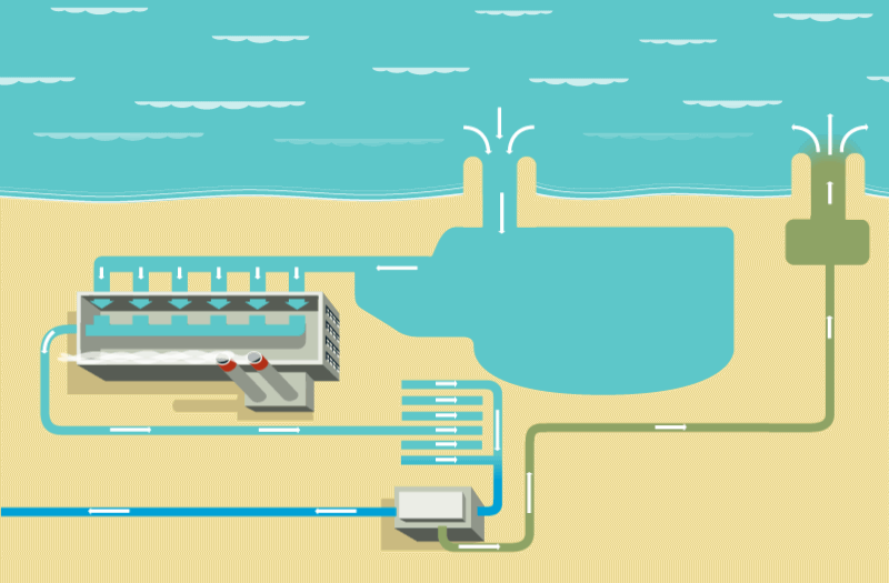
How It Works
Scientifically, it is quite simple to create clean drinking water from salt water. The most common method is reverse osmosis, which puts water under immense pressure to filter out salt, minerals, and other unsafe bits. The large amount of energy required to create that pressure is a major reason we haven't seen a desalination-plant building spree. Energy accounts for as much as 40 percent of the hefty cost of the process.
How It Doesn't Work
If desalination plants are powered by fossil fuels, there is also a planetary cost, exacerbating future droughts and creating a circular climate issue. The annual emissions from a large desalination plant can equal those of more than 50,000 cars during the same period.
Even a desalination plant powered by renewable energy faces the second hurdle: brine. The leftovers from desalination are concentrated salts mixed with chlorine and copper. This saline sludge is dumped back into the ocean, which increases ocean acidification and can be deadly for marine life.
[Illustration shows a house with a small desalination system on the roof.]
How It Could Work
The National Renewable Energy Laboratory proposes harnessing the power of the salty waves themselves as a net-zero way of pressurizing municipal desalination plants.
Another option might be off-grid, household desalination systems using low-cost materials. Researchers at MIT and Shanghai Jiao Tong University have designed one small enough to sit on a rooftop but efficient enough to make about a gallon of drinking water per hour. Instead of reverse osmosis, the system relies on distillation: Solar heat (captured by blackened glass panels, not solar cells) evaporates water, leaving the salt behind; the recycled heat then condenses the vapor back into a potable liquid. Instead of electrified pumps to bring the salt water in, the tool relies on the power of gravity to passively draw salt water through several filters. The byproduct is still salty brine but without toxic chemicals. Researchers are working on getting rid of the liquid entirely, leaving only salt crystals—the same kind one might use to season dinner.
The Upshot
Desalination—without excessive energy costs or toxic byproducts—is at present probably best achieved by scaling up passive, inexpensive systems designed for individual coastal households. Bonus: Such systems could be cheaper for a family to run and maintain than paying their usual municipal water bill.
Source article at Sierra Magazine
Note: Ventana Chapter is currently opposing a massive, unneeded desalination plant in the City of Marina in Monterey County. In addition to the serious threats to the marine environment and local water supplies, there are consequential environmental justice issues. The community of Marina has a large percentage of low income and marginalized populations. The negative impacts of a complex desalination plant at this site is an egregious example of poor land use and a violation of environmental justice. The Sierra Club has long held a position on environmental justice that when environmentally damaging projects are proposed, they should not be systematically placed only in communities of color and the disadvantaged. These very communities in the City of Marina will be those most deprived of free and easy access to the beach for appreciation of the coastal views, walking and other recreational opportunities.
 Richard looking up at a ski trail marker. Richard looking up at a ski trail marker.
Mariposa Grove
December 26, 2023
by Debbie Bulger
photos by Debbie Bulger & Richard Stover
This was planned as a ski/snowshoe trip. Mother Nature had other plans.
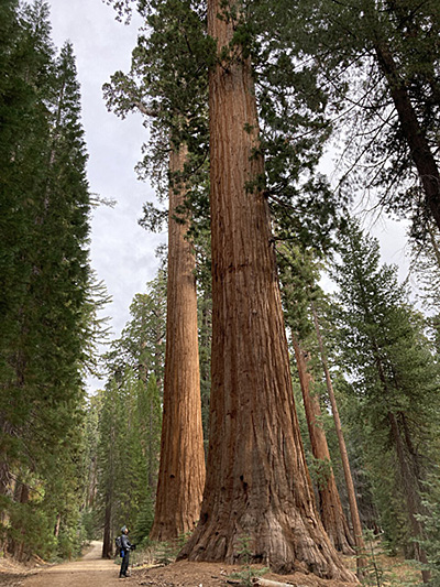
We hadn’t been to Mariposa Grove in Yosemite National Park since the park restored the site where giant sequoias tower over visitors. The Grove was closed to visitors from 2015 to 2018 while the $40M project was underway. The result is a markedly more peaceful and inspiring experience for visitors and a major restoration of sequoia and wetland habitats.
Parking was relocated to two miles from the grove with shuttle service in summer and a trail to the grove. Commercial services were eliminated, paved roads replaced by accessible trails and hydrology restored. For a 4 minute video about the changes visit, https://www.nps.gov/yose/planyourvisit/mariposagrove.htm
Since we were visiting in the winter, there was no shuttle. The welcoming center has wonderful displays and interpretive panels including a statue of a fisher, an elusive member of the weasel family. In all my years of backcountry travel I have seen only two.
 Debbie sitting next to Fisher statue. Sequoias in background. Debbie sitting next to Fisher statue. Sequoias in background.
|
 The Grizzly Giant The Grizzly Giant
|
Perhaps the most massive tree in the grove is the Grizzly Giant, estimated at over 2700 years old.
Just beyond the Grizzly Giant is the Tunnel Tree carved in 1895 for stagecoaches. We know better now. |
 Richard at the Tunnel Tree. Richard at the Tunnel Tree.
|
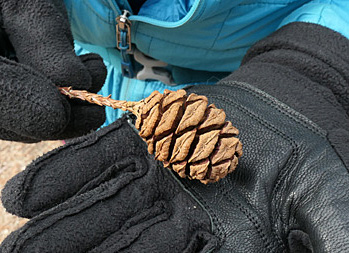 Sequoia cones contain about 200 seeds.. Sequoia cones contain about 200 seeds..
Beyond these two titans visitors thin out considerably as the distance to the parking lot from these trees is three miles making for a 6-mile round trip in winter. We continued on to Wawona Point and sights beyond making for an 11.5-mile hike with about 1600 feet of gain on well-developed trails.
The enormous sequoia trees spring like their cousin redwoods from a small seed. Sequoia cones are larger than redwood cones and contain about 200 seeds.
Even for folks like us living near redwood trees, these trees are awesome. In their presence one realizes just how small humans are. |
 Richard gazing up at a Sequoia. Richard gazing up at a Sequoia.
|
 The route is replete with old roads and new cow paths. The route is replete with old roads and new cow paths.
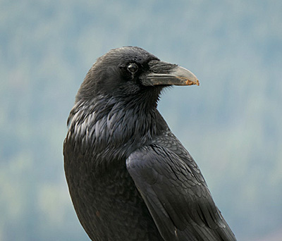
We were greeted by a Raven when we reached Wawona Point.
This one had little fear of people and posed for a photo alongside us.
|
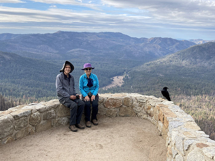 From Wawona Point we could almost see the cabin where we were staying. From Wawona Point we could almost see the cabin where we were staying.
|
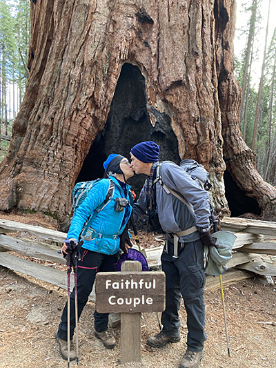
The highlight of our hike was an up close view of a White-headed woodpecker dining on insects on a fused double-trunked tree called the Faithful Couple.
A moment to remember. |
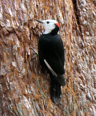 A male white-headed woodpecker. A male white-headed woodpecker.
|
|
|
Make a contribution to the Sierra Club today!
Your local Sierra Club Chapter and Group needs financial support to carry on our fight to protect the spectacular coast, valleys, and mountains.
We cannot fight for endangered and at risk wildlife without money. We cannot save precious forests, mountains, watersheds, and open spaces without money.
We know that you care about the environment from your membership in the Club. Now we need your help.
Much of the work of the Club consists of non-glamorous, roll-up-your-sleeves labor. Volunteers study EIRs and make comments; activists get government staff reports and keep tabs on proposed developments and policy changes; sometimes the Club files suit.
Please help us continue to protect and preserve the Central Coast. To make a donation please send a check made out to ‘Sierra Club' to
Sierra Club Ventana Chapter, P O Box 5667, Carmel, CA 93921-5667
Contributions to the Sierra Club are not tax deductible. To send tax deductible contributions, which mainly support legal actions when they become necessary, make your check out to ‘Sierra Club Foundation' instead.
|
|